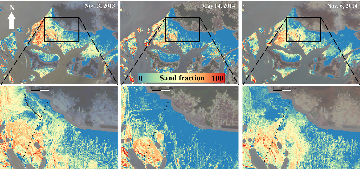
🐚 Tidalflat - Nature's true source of life 🐚
This incredible ecosystem is submerged half the day, constantly shifting as tides ebb and flow.
South Korea's mudflats span 2,443.3 km² (about 4x Seoul's size!), requiring advanced monitoring approaches
beyond traditional drone and vessel surveys.
Our research leverages 🛰️ SAR satellite imagery 🛰️ to observe mudflats consistently regardless of weather conditions.
By analyzing pixel brightness, exposure timing, and capture dates, we can map tidalflat topography and exposure frequencies.
This research is crucial for developing monitoring strategies as we face global sea level rise and coastal environmental challenges.
radar remote sensing
geospatial information
tidal flat
What We Do
💧 Hydrological research with LIS! 💧
Our lab is developing high-resolution hydrological models of the Korean Peninsula using the Land Information System (LIS) — a software framework that integrates satellite data, in-situ observations, and advanced data assimilation techniques. LIS allows us to simulate complex hydrological processes and quantify key water cycle components.
Applications include: 🌊 forecasting floods and droughts · 💧 optimizing water resource management · 🌱 supporting data-driven environmental policy and decision-making.
land information system water resources
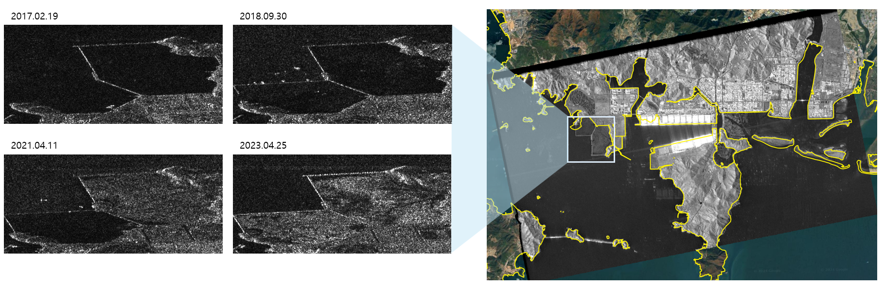
🛰️ SAR satellite imagery for change detection 🛰️
Once mostly used in engineering and military contexts, satellite data is now helping us analyze national economies and predict global crop yields. This research uses time-series satellite imagery to monitor reclamation projects and facilities in public waters, creating effective monitoring algorithms that support policy decisions.
This research combines remote sensing technology with public policy to provide data-driven insights for the management of shared coastal water resources.
geosciences remote sensing
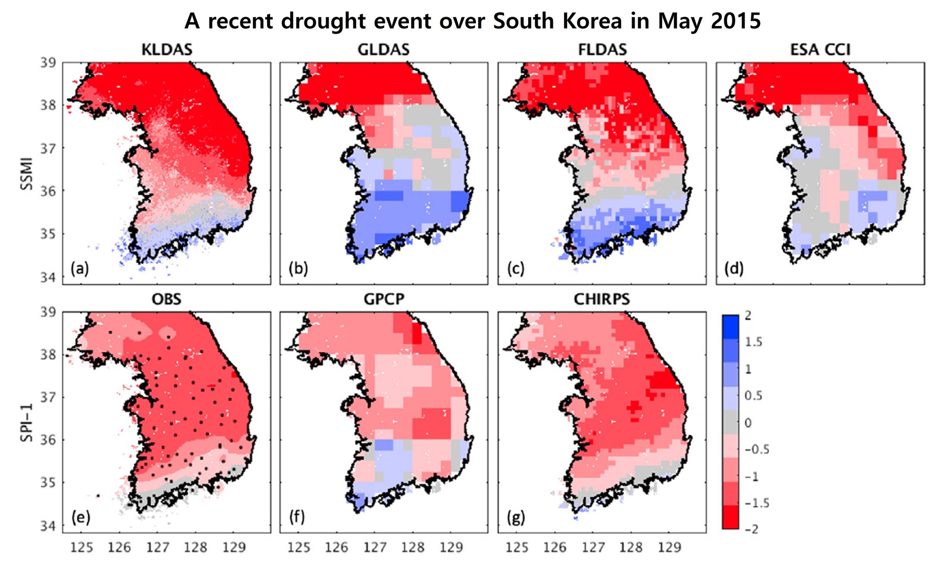
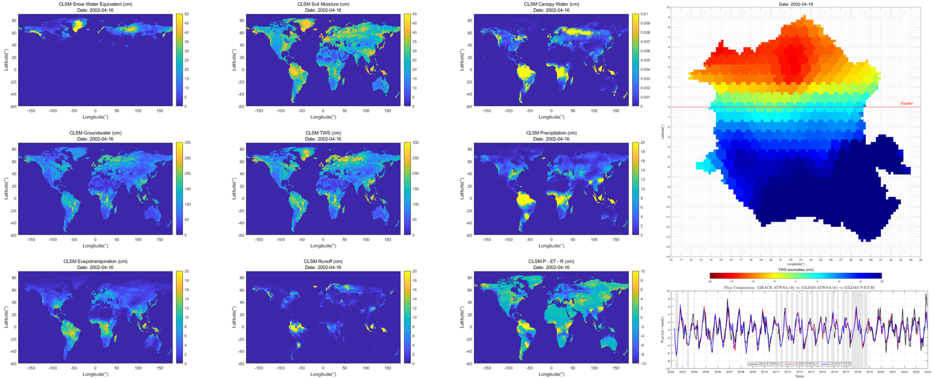
🌏 Measuring Earth's water storage with satellite? 🌏
The GRACE satellites fly in formation, precisely measuring distance changes between them caused by Earth's gravitational variations. Our research overcomes GRACE's biggest limitation — coarse spatial resolution (~330 km) — by developing statistical downscaling techniques that combine GRACE data with various numerical models.
Applications: drought/flood prediction, groundwater depletion monitoring, and sea level variation analysis. 😎
GRACE water resources
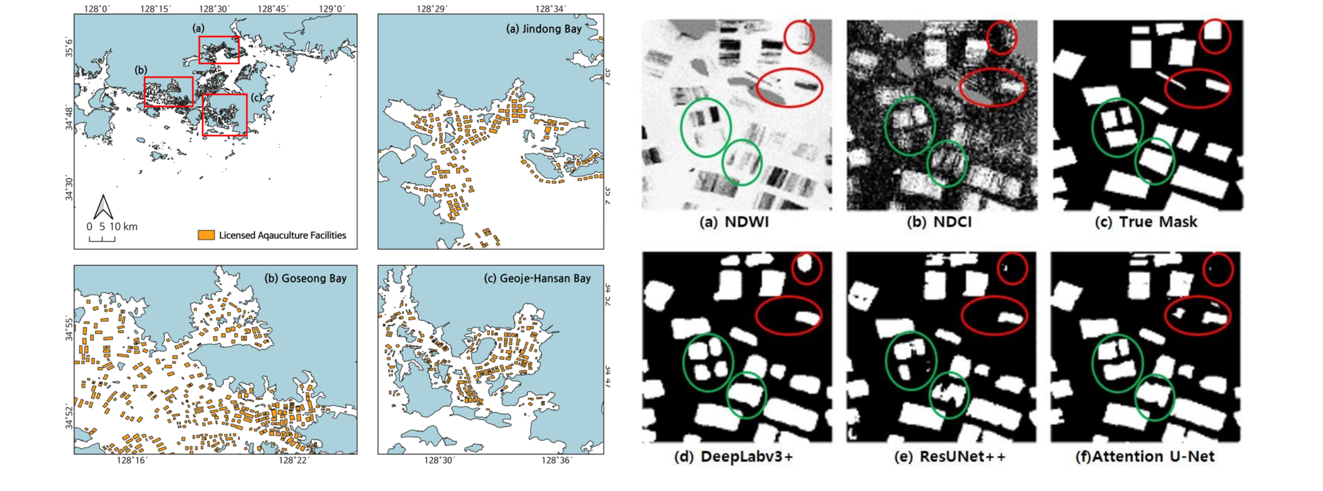
🤖 Remote Sensing × AI research from our lab! 🤖
The complex coastal environment creates non-linear relationships between aquaculture facilities and their spectral reflectivity, making traditional threshold-based detection methods insufficient. We address these challenges by combining multi-satellite imagery with AI techniques to detect nearshore aquaculture facilities along Korea's southern coast.
This fusion approach extracts complementary information from different satellite sources, compensating for individual sensor limitations and building foundational datasets for comprehensive environmental monitoring. 🔥
AI aquaculture facility coastal environment management
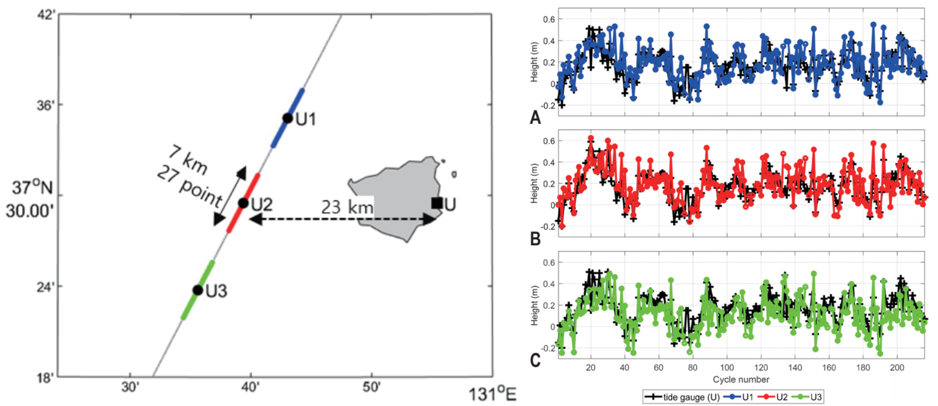
🌊 Advancing Coastal Altimetry: Overcoming Challenges in Sea Level Measurement 🌊
Satellite altimeters measure sea surface height by measuring the round-trip time of radar pulses. In coastal regions, signals are contaminated by surrounding terrain, producing distorted waveforms. Enhanced technologies like SAR-mode and FF-SAR-mode altimeters utilize the Doppler effect for higher resolution.
We develop processing techniques specifically optimized for coastal environments using these advanced altimeter modes.
Remote Sensing Altimeter Sea Level
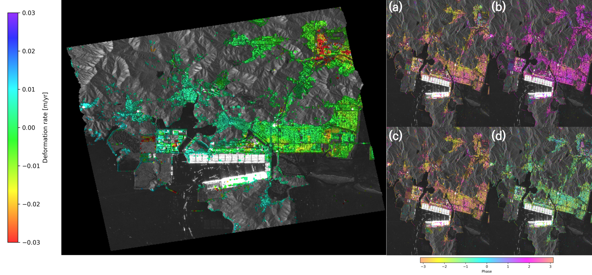
⛰️ Subsidence Monitoring via Time-series SAR Interferometry ⛰️
We apply Persistent Scatterer Interferometric SAR (PSI) to monitor ongoing ground subsidence. SAR works regardless of weather or time of day, making it ideal for continuous monitoring. By analyzing multiple SAR images of the same location over time, we create precise time-series measurements of ground movement.
This approach detects subtle changes impossible to observe through traditional field methods, providing critical data for infrastructure safety and urban planning.
PSInSAR Interferometry SAR