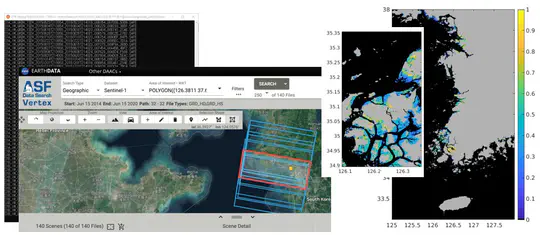
This research focuses on analyzing the spatiotemporal dynamics of coastal wetlands through advanced imaging radar technology. We utilize synthetic aperture radar (SAR) data to monitor changes in tidal flats and wetland ecosystems, providing valuable insights for environmental management and coastal conservation efforts.
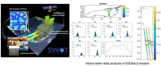
Our laboratory develops innovative methods for analyzing satellite altimeter data to monitor sea level changes, ocean currents, and water bodies. This research improves the precision and applications of satellite altimetry, contributing to ocean science, climate change studies, and water resource management.
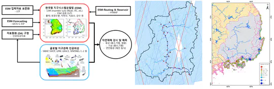
This interdisciplinary project integrates data from multiple satellite platforms with Earth system models to enhance monitoring and prediction of natural hazards in terrestrial and coastal regions. Our research aims to develop comprehensive frameworks that improve early warning systems and resilience strategies for communities vulnerable to environmental disasters.
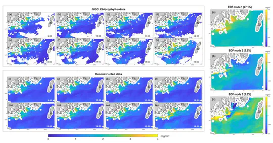
Our team is developing advanced algorithms to address the challenge of missing data in Geostationary Ocean Color Imager (GOCI) observations. Using innovative statistical and machine learning techniques, we reconstruct spatiotemporal gaps to provide continuous monitoring of ocean color dynamics crucial for marine ecosystem research.
This initiative focuses on strategic planning for Earth observation satellites and maximizing the scientific utility of satellite data. We investigate optimal sensor configurations, orbital parameters, and data acquisition strategies to enhance our understanding of Earth system processes and address pressing environmental challenges.
As satellite technology advances, our laboratory is at the forefront of developing methods to handle and extract value from the resulting big data. We create innovative geospatial data processing techniques, cloud-based analytics platforms, and visualization tools that transform satellite big data into actionable geospatial intelligence.